Not the prisoner of Assekrem more the hermitage of Charles de Foucauld
Algeria 20 Feb 1979 to 9 Mar 1979
2 to 6 March 1979
After the splendid Djanet and the prehistoric rock art we set off back to Bordj El Haouas skirting the Tassili N'Ajjer National Park. Retracing our steps for 140 km before turning again towards Tamanrasset. From one set of superlatives to another.
For non Harry Potter fans the film was Harry Potter and the Prisoner of Azkaban, there were no prisoners on our trip that I am aware of.
We headed from Tassili N'Ajjer National Park to the Ahaggar National Park on route from Djanet to Tamanrasset which is shown on Google Maps as being 670 km via Assekrem. Not very far in comparison.
Skirting around the edge of Erg d'Admer full of more magnificent sand dunes. Bing Maps indicates a road through the middle of the Erg but I don't think we did that. There is enough sand at the edge. The track could easily be relatively straight but instead tries to follow some of the outcrops of rock at the merging of the Tasslli with the Erg. Fingers of rock into the sand, or is it sand into rock. Taking the shortcut between one finger and the next would not necessarily result in any time saving, dependant upon how long it takes to dig out of the deeper soft sand. Inevitably, there are still many sections where sand it is, with no rock outcrops to navigate around. Touching the bottom of some of the dunes and crossing dry river beds that can still be seen in the satellite photos of the area on Bing Maps. We arrive back at Bordj El Houasse and turn left to cross the wide dry river bed. Not quite as dry as some as there are a few trees on the bank and scrub in the bed. It's amazing to my mind that some of these dry river beds are 200 to 700m wide. A quarter of a mile or more, in one of the driest warm deserts in the world. The area makes it into the 10 driest places on earth. The Thames in London, at Waterloo Bridge, only slightly less than 300m or 1000ft. The Thames flowing through the Sahara is beyond imagination.
Out of the Erg and on the way to Tamanrasset the whole sand scene changes. It is more flat and homogenous. Flat sand as far as the eye can see. There are occasional mounds and outcrops, which are both navigation aids and a break in the monotony. There even more dry river beds to cross suggesting a vast ancient river system in the area. The beds look and feel different to the surrounding sand. The ergs are sand staked up into dunes based on the prevailing winds, with longitudinal valleys, crossed occasionally by transverse dunes, just to keep the variety going. A sea of sand waves. Now we are in a sea becalmed.
Somewhere we cross from the Illizi Province to the Tamanrasset Province without any sign in the sand. Nothing to mark our progress in any shape or form. Look to the position of the sun in the sky to check that you are still going forward in vaguely the right direction. This is the main road across the base of Algeria and it is in places barely discernible.
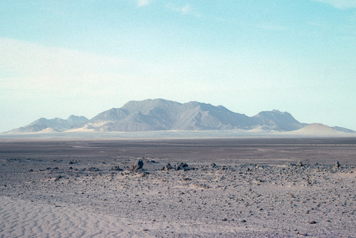
A small rock outcrop stands up out of the flat desert. Perhaps more far away than small, as it is about 20km away and stands about 700m from its base in the desert floor, itself over 1000m in altitude. It is a mountain called Toukmatine and info can be found here.
There is another thing to break the monotony, a little exercise. Sat in the back of a truck through fantastic scenery with astounding experiences is one thing, but when the scenery flattens and the experiences pace themselves, it can become a little dull. What better than to get stuck in soft sand. The sand mats come off the side of the truck and the shovels are broken out. It is actually quite a skill for the team to be able to use sand mats well, with a good deal of coordination. Health and safety would probably preclude this technique these days. The truck is in Low FWD. Dig out the wheels, front and back on both sides, enough to be able to place the sand mats at a reasonable angle. The height of the truck between the wheels limits the angle there. Once in place a little rocking of the truck with the engine will eventually have the wheels out of their self created pits and onto the sand mats. Then it is important to maintain momentum. Momentum will have it moving on top of the sand instead of digging some more pits for itself. This momentum maintenance is aided by a well practiced team. The truck pulls up the sand mats until they flatten, and then along them, with the rear wheel mats spat out of the back before the real wheels engage with the front mat, just released from the front wheels. As soon as it is spat out the back the collection team on each side, pick it up together and run quickly round to the front of the truck to place it under the front wheels whilst the truck is still driving towards them. Don't fall over, don't drop the sand mat before it has engaged with the front wheels, and let go quickly when it does. Look out you are just about to get run over by your home and transport. Another collection team do the same whist you run to collect the mat from the back again. Repeat until you are out of that section or the driver manages to get enough momentum to keep going without the mats. In which case you have to run after the truck, with the mats, until the driver thinks it is prudent to stop and wait for you without sinking into the sand again on setting off. Mats back on the side of the truck, and shovels stowed. Perhaps the sand mats are not strapped down tightly as it is expected that they will be used again soon. Everybody back in the truck and sitting comfotably? Then we commence again. How far shall we get before a repeat performance. All this on a track that is maked on the map, not dune running for fun. It is not a dune buggy for playing that sort of game.
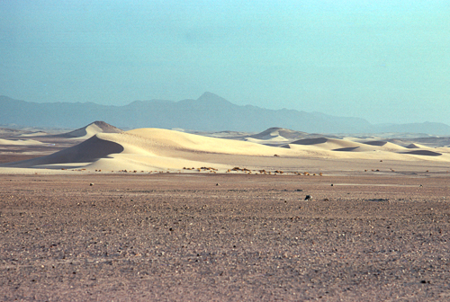
More of the same, and more, but with the occational string of wind swept sand dunes. Dunes dwarfed by the mountains of Ahaggar National Park in the background, on the route between Bordj El Haouas and Idlès.
Another dry river bed comming off the Hoggar Mountains, over one km wide. There was water here once.
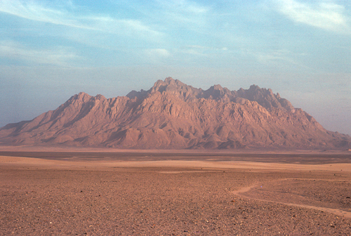
Another splendit rock outcrop, even bigger, climbing to an altitude of 2360m at the peak, a mear 1800m at the front ridge, all from a flat base of 1200m.
Time to stop before entering the mountains.
I don't know, but I would guess that the route of the track, as it was at that time, was created by the experiment and experience of our predecessors. Some brave soul tried to get from a to b in a vehicle along the route a few camels have travelled over a few decades or more. They get stuck somewhere. The next person along sees the disturbance and seeks to find firmer ground. Repeat over numerous years to optimise the route. Many more years required to fully optimise the route, but there will always still be some problem areas that can't be avoided and sometime the ground will change, the shifting sands of time. Perhaps the government will eventually get round to building a road, and spoil the whole experience.
A couple of exposed rock outcrops to drive between, and then a river bed to drive along instead of just to cross. Most of the flatish area was at an altitude of 1000m, but now we are beginning to climb and the higher ground is closing in to put us in valleys. The ground has hardened. The peaks around us are over 1200m. The road is still winding,but instead of avoiding soft sand, it is following valleys. Along the edges of dry river beds instread of in them now. Sometime crossing from one side of the vally to the other.
The track widens out as the terrain flattens again. The ground is firm so there is no need to stay on a single track. The road becomes multiple tracks over 300m wide and narrows again for obstacles such as crossing yet another dry river bed. Again there are many of these and quite a few of those have scrub growing in them. The only vegetation appears to be in the dry river beds. more soft sand, just to mix it up a bit. Slowly moving into a more rocky area.
Now we are entering to land of pimples and sand covered valleys. Closer together and steeper sides. About 1300m now with the adjacent peaks over 1400m. Another dry river bed, about 300m wide, but with low trees this time instead of just scrub. Just scrub, in the Sahara this should not be dismissed that lightly.
Suddenly the sand ends and we are on rock. We are in the mountains proper. More sunburnt rocks as described inTassili N'Ajjer National Park article. We are above 1400m now, in the valley floor.
Looking at the map whilst writing this I found information on the areas' hydrographic features and a place called Idlès, which is on our map, but I don't recall visiting the place. At the time there was no Garmin, or Tom Tom, or any other satnavs. In fact the first satellite for GPS had only been launched the year before our trip but it would be many years before you could look at a satellite image on a home computer or buy a satnav. There are very few signs pointing the way, sometimes blocks of stones with painted places and distances. Even they are easily missed as the tracks vary in position. It is therefore not particularly incredible to find that we were barely a mile away but did not know about Idlès.
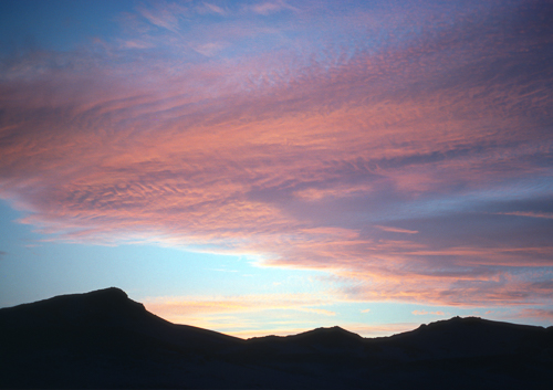
Onward, towards the mountains and yet more sand in the valley floors. We are still climbing and have left the sand behind us. Spectacular rock formations, mountain passes exhilarating views. Slow progress as we keep stopping for photos. Up to a seriously high elevation of more than 2300m in the valley with rock stacks and pinnacles towering up to 2918 at Assekrem.
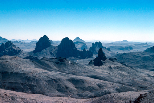
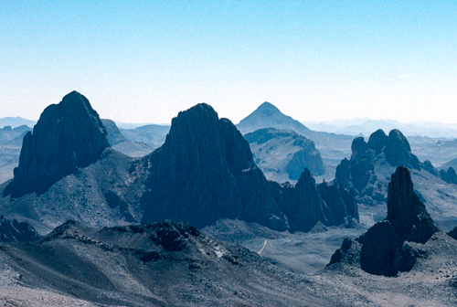
Séouénane Pass, Tizoûyadj, Hoggar Mountains
Another stop at the Ermitage du Père de Foucauld and then we were on the tourist circut around Tamanrasset.
People!!
Then the excitment of Tam. Just for a more recent flavor, I found this video.
A video with the same view. But then play it from the begining to get a flavor of the area with improved roads. And this video shows a different element.
Photo galleries powered by SmugMug
To see the photos of this article in HD follow this link to my photo gallery site. Click here.,
Map of North Africa with approximate route from Djanet to Tamanrasset, through the Hoggar Mountains. Click on the camara icons to see some of the photos.
Sources used to identify places; Google Maps, Bing Maps, Geographical Names, YouTube, Maps for the world, Mapcarta, Ermak Travel Guide, Flickr Hive Mind, Alamy stock photos, Geoview info, Thinklink, Thousand Wonders, Les balades de Bibi, The pages of Nezumi, IDEOZ, TrekEarth, Mapcoordinates, Getty Images, Research Gate, Sahara Overland, A Lovely World
Back to Contents and navigation


